There is quite a bit of work involved in planning the route for your cycling adventure. You need to consider really exciting things like how long it will take you take you to get to the end of the route, what the weather will be like, where should you be stopping for the night, etc. The exciting stuff comes when you start your journey, but some planning before you leave will add to your enjoyment of the moment and, hopefully, avoid some headaches along the way.
Distance
A good place to start planning is by working out the distance of the cycling tour. When I first started planning my trip, I used Google Maps to plot a rough route to find out how far I’d agreed to ride. That map is still in use as I continue to plan the route in more detail.
Google Maps will plot your route along major roads, you can also adjust the route manually. The software will calculate the distance of your route, saving you some guesswork.
Time
 “It’s the journey not the destination that matters.”
Most touring cyclists are not out to beat the record for the fastest ride between A and B. With that in mind, you will need to plan the trip to fit comfortably within the amount of time you have available.
Work out the average distance you want to cover in a day (or a week) and use that as your guideline for how long the trip will take you. It is better to work the time out from the average distance per day, as this method allows you to work from the perspective of participant comfort, something which your body and/or your companions will thank you for at the end of the day.
Number of days = total distance ÷ daily average
Of course, if there is a particular route you’ve been dreaming of completing and you only have three weeks of vacation, then working out the daily average required (and then not fainting when you realise the result) is a better method for your purposes. Although, if you wish to complete a 6000km route in three weeks (@~285km per day) another option you might want to consider is doing it in two or more stages.
Daily average = distance ÷ days
I have the luxury of no real time limit (barring of course the expectations of family that I will one day grow up and rejoin ‘normal’ society) so I’m planning on an average of 50km per day over the whole trip. This figure will allow quite a few rest days when the going is good, but take into account that 50km through the mountains of southern Sichuan is a really long day by anyone’s standards.
Climate
Researching the climatic conditions you’ll experience on your tour is critical as this will impact your decisions about clothing, accommodations, water, and food to name just a few.
There is a wealth of information available on the internet that can assist you. When I’m planning any trip away I use the wunderground site, particularly their historical weather data.
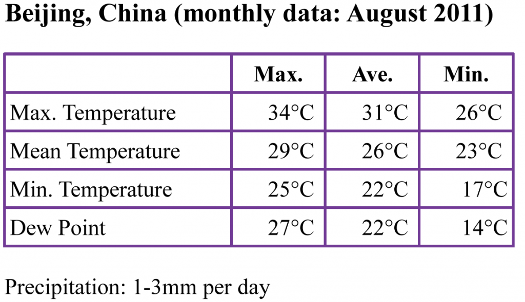
The following is a summary I developed using the wunderground data. It provides a good overview of the conditions around Beijing during August, which is when I’ll be starting out. It looks like it’s going to be hot, wet, and uncomfortable, but with the chance of some really good days on the road.
Dew Point is a very handy piece of data to have as it effectively represents how comfortable you will be. A Dew Point in the range 10-16°C is considered “comfortable”, above 16°C most people will begin to feel the humidity and comfort lessens.
Maps
You will definitely need some sort of navigational ability on your trip. My preference is for paper maps over GPS because maps aren’t subject to the whims of batteries and power supplies. Also, paper maps are generally cheaper than a GPS unit, not to mention the country specific map data that averages about $70 a pop. GPS is good for navigating out of major cities, however, and if you are willing to spend the cash, one could come in really handy in a congested, dubiously planned, Asian capital.
A good compromise is paper maps backed up by a smartphone with GPS capability and free navigation software (I use Google Maps on an iPhone) which, where a data connection is possible, can help you navigate out of urban areas. Mobile data is very reasonably priced in Asia and a local SIM can be readily obtained from a corner store.
Good paper maps are hard to come by in China. You can often only purchase a provincial map for the area you are currently in, and they are only available in the Chinese language. Occasionally there are maps for other provinces available, but not many. I found that I really only used the paper maps to plot my route through the provinces and, because they lacked detail, relied heavily on my smartphone for day-to-day navigation. The maps were a handy tool to engage locals as they loved seeing where I had been riding, where I was going to, and finding their own village on the map.
Next Page: Accommodation
Planning your cycling tour:
Is our information useful????
This website has been created to support our fundraising efforts for research into a cure for Melanoma. If you found this information useful, please consider making a small donation.
